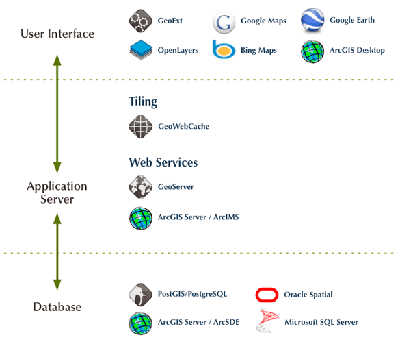
OpenGeo Suite
The OpenGeo Suite combines the power of open source plus the reliability and support of a single, stable vendor behind a full stack of software. It delivers functionality and flexibility for enterprises large and small.
Interoperability with Other Providers
Our stack is not designed to lock you in, but to complement and improve your existing implementations. By developing each individual component of the OpenGeo Suite individually we ensure that each is used in a number of different configurations. This guarantees that the Suite works well with most existing systems—proprietary or open source. Learn more about how the OpenGeo Suite integrates with Google, Oracle, ESRI, and Microsoft.
Google and the OpenGeo Suite
Looking for a scalable solution to combine your data with Google's mapping infrastructure? The OpenGeo Suite excels at Google Maps and Earth integration, connecting directly to your existing database, no matter how large. When you need more control over your application, GeoExt and OpenLayers provide a framework for creating custom controls and allowing you to build a solution tailored to your users.
Enterprise connectivity
Put your existing Oracle, SQL Server, ArcSDE, DB2, or PostGIS database on to Google Earth or Google Maps faster than with any other solution. The OpenGeo Suite provides true enterprise connectivity by reading directly from the database instead of pre-generating a number of tiles.
OpenGeo's open source base and expertise in both enterprise spatial databases and Google Earth let us tailor a custom solution to your most challenging requirements. We' been twice funded by Google to help improve Google Earth connectivity to existing databases, including automatically creating ‘Super-Overlays’ from enterprise databases to enable Google Earth to read gigabytes of data without being overloaded.
Custom applications
Take your Google Maps and Google Earth Plugin applications even further with GeoExt and OpenLayers—core parts of the OpenGeo Suite providing a flexible set of mapping, editing, and analysis components that combine easily with Google's tiles and Earth plugin.
Editing
OpenLayers provides vector editing capabilities previously only available on desktop clients completely in the browser, including snapping, splitting, and basic shared boundary editing backed by GeoServer and the WFS-T standard. With the OpenGeo Suite, make edits from the browser directly to an enterprise database all directly on top of Google Maps tiles.
Analytics
Why purchase an expensive GIS and the training to use it properly when you can design custom applications that harness the analytic power of GIS in a simple and approachable way? Building on Google Maps or Google Earth can make people feel more comfortable using your application while GeoExt allows developers to leverage existing components to rapidly create custom applications. GeoServer and its open standards open up the door for more advanced analytic capabilities.
Google Earth Plugin
Put Google Earth directly within the browser with the Google Earth plugin or use the full power of GeoExt components to control the globe with the Google Earth panel.
Speak the standards
Your data is not just available on Google, it's available to all. The OpenGeo Suite implements the OGC's WMS, WFS, and WCS standards—making all your data instantly accessible. It also provides tiles as TMS, WMTS, WMS-C and native Google Maps and Bing Maps formats. And data is available as GML, JSON, Shapefile, CSV, Excel and more.
Oracle and the OpenGeo Suite
Looking to get more out of your Oracle deployment? The OpenGeo Suite brings a number of additional geospatial capabilities to the Oracle platform, including better support for Open Standards, Google Earth connectivity, and best of breed tools for browser-based geospatial applications. All functionality works against both Oracle Spatial and Locator (standard in all Oracle installations).
Standards
The OpenGeo Suite exposes your database to a wide variety of open standards and formats—the Suite is certified compliant for the OGC WMS, WFS and WCS standards and data is instantly available as GML, JSON, Shapefiles, CSV, KML, Excel, PDF, and SVG—which gives developers plenty of options. The OpenGeo Suite also has great support for Styled Layer Descriptor, so you can define your map rendering rules in an open way. With GeoWebCache, the OpenGeo Suite exposes tiles as WMTS, WMS-C, TMS, Google Maps, Bing Maps, Mobile GMaps and even as WMS for consumption by a variety of clients.
Get on Google
The OpenGeo Suite is the fastest way to get your Oracle Spatial Database on Google Maps or Google Earth. By leveraging tiling and caching and making use of Super Overlays to stream data efficiently, the OpenGeo Suite enables you to serve gigabytes of real vector data without overwhelming Google Earth. Try out the Oracle Importer in the OpenGeo Suiteo and see the results on Google Maps and Google Earth.
Custom applications
Create compelling applications based on your Oracle data with the OpenGeo Suite. Looking for editing capabilities? Full integration with open standards and commercial providers? A huge community of people who can offer advice and custom functionality improvements? Most developers who explore options outside of MapViewer are instantly impressed with all that's available in OpenLayers and GeoExt. The OpenGeo Suite gives you a great introduction to those components while OpenGeo also offers a variety of training classes and core developers who can handle any unique requirements.
ESRI and the OpenGeo Suite
Want to break out of the silo? The OpenGeo Suite integrates with your existing infrastructure while speaking open standards and interoperating seamlessly with Google Earth and Maps. We emphasize a hybrid architecture that lets you swap in open source components where it's most appropriate.
Developer-friendly Javascript components
OpenLayers and GeoExt are built to speak to ArcGIS Server and ArcIMS directly and can communicate with ESRI's WMS implementations. Both offer a large advantage over ESRI's Javascript API as new features from a number of sources around the world mean the pace of innovation is hard to match. Many leading ESRI integrators are already making use of OpenLayers—just look at James Fee's great presentation at the 2009 ESRI Developer Summit on “Using OpenLayers with ArcGIS Server REST API”. Make future transitions easier with front-end solutions developed to work seamlessly against a variety of backends.
An independent cache
While ArcGIS Server offers an included cache, it is also possible to use GeoWebCache for better Google Earth connectivity, native connections for Google Maps and Bing Maps, tiling standard support (WMTS, TMS, WMS-C), and a developer-friendly REST API to script cache seeding and more. GeoWebCache offers much more granular control over the cache than ArcGIS Server offers, even recombining tiles on the fly to serve as a direct WMS.
The OpenGeo Suite and ArcSDE
Many of our clients use ArcSDE as an enterprise geodatabase but leverage the OpenGeo Suite for its strengths in web connectivity, open standards, and Google Earth and Maps support. Clients with this configuration enjoy very solid ArcSDE support, including full vector and raster capabilities with great performance, connectivity to versioned tables, and special queuing of requests to handle limited licensed connections. These optimizations make the OpenGeo Suite one of the fastest way to serve data directly from ArcSDE.
Backed by PostGIS
ArcSDE can also use PostgreSQL/PostGIS as a cost-effective alternative to SQL Server or Oracle Spatial, enabling future migrations to more open source components.
Microsoft and the OpenGeo Suite
The OpenGeo Suite brings open standards and enterprise capabilities to Microsoft's mapping products and fills a hole in Microsoft's geospatial offerings. Our middleware components sit in between the application tier (Bing Maps) and the database (SQL Server) to provide a full enterprise web-mapping solution and our front-end components extend Bing Maps capabilities to standards-based geospatial applications with more complex requirements. Bringing standards to a Microsoft-based infrastructure enables a more diverse developer ecosystem to access and improve on data.
Open your SQL Server
Connecting the OpenGeo Suite to your existing SQL Server 2008 geospatial databases makes your data available for integration with nearly every platform through either open standards and custom connectors. Want to get on Google Maps? Expose raw data as GML, GeoJSON, CSV or Shapefiles through the Web Feature Server interface? Stream gigabytes to Google Earth? Render beautiful maps to any GIS through the Web Map Service standard? Edit data through-the-web with the WFS-T open standard? The OpenGeo Suite handles it all, while also enabling you to control role-based security access and build custom geospatial applications. Please get in touch if you're interested in trying the SQL Server plugin.
Build rich standards-based applications with Bing
The OpenGeo Suite supports a number of integration points with Bing Maps. GeoWebCache natively brings fast tiled access to any WMS Server via the Bing Maps API. Any data cached by GeoWebCache is also instantly available on Google Maps, OpenLayers, Google Earth, and as WMTS and TMS.
OpenLayers and GeoExt can use Bing as a base layer and provide a flexible set of components to create web applications geared towards your needs. Use the OpenGeo Suite to perform web-based editing like snapping and splitting with Bing as a base, saving the data updates to SQL Server or any other database. The support of OpenLayers for a wide variety of geospatial formats ensures that your web application will be able to handle changing requirements from diverse systems.
More about OpenGeo Suite
www.opengeo.org
To know more about OpenGeo Suite and how it can help you implement your next Enterprise Geospatial Solution and have a better ROI, contact us through sales@geoicon.com or use our webform. Our consultants will attend to your queries soon.